
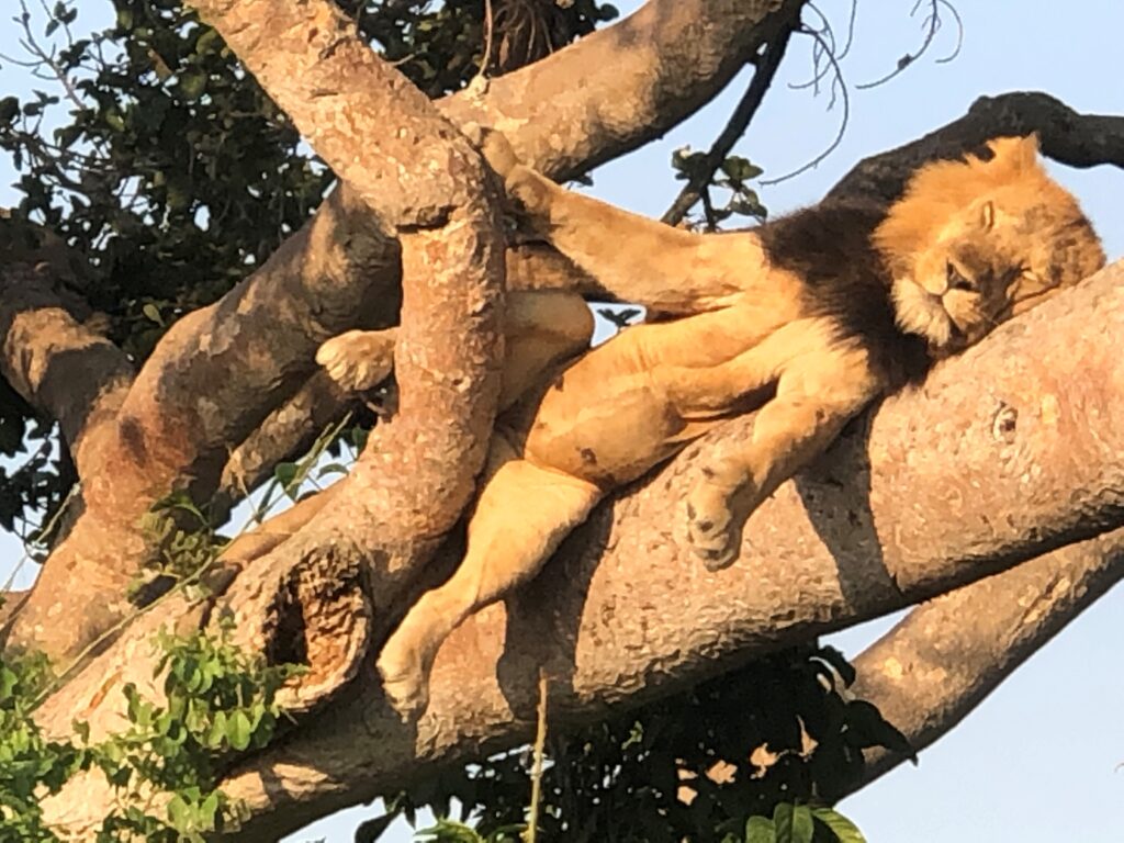
Ishasha Sector of Queen Elizabeth National Park, Uganda
The Ishasha sector of Queen Elizabeth Conservation Area (QECA) is part of the Greater Virunga Landscape (GVL), an important transboundary ecosystem and one of the most biodiverse landscapes on earth. The Ishasha sector (535km2) includes southern Queen Elizabeth National Park (QENP), incorporating Southern Maramagambo Forest, and Kigezi Wildlife Reserve (KWR).
Encompassing various ecosystems – savanna grasslands, acacia savanna, wetlands and tropical high forest – Ishasha is popular with tourists drawn by the world-famous tree-climbing lions and mega-aggregations of elephants. However, the area and its wildlife face multiple threats, including significant levels of subsistence and commercial poaching and human wildlife conflict (HWC). Tree climbing lions in Ishasha have been on the steady decline over the last 30 years. Poaching through snares and poisoning by local communities is the greatest threat to their survival.

Kidepo Game Reserve, South Sudan
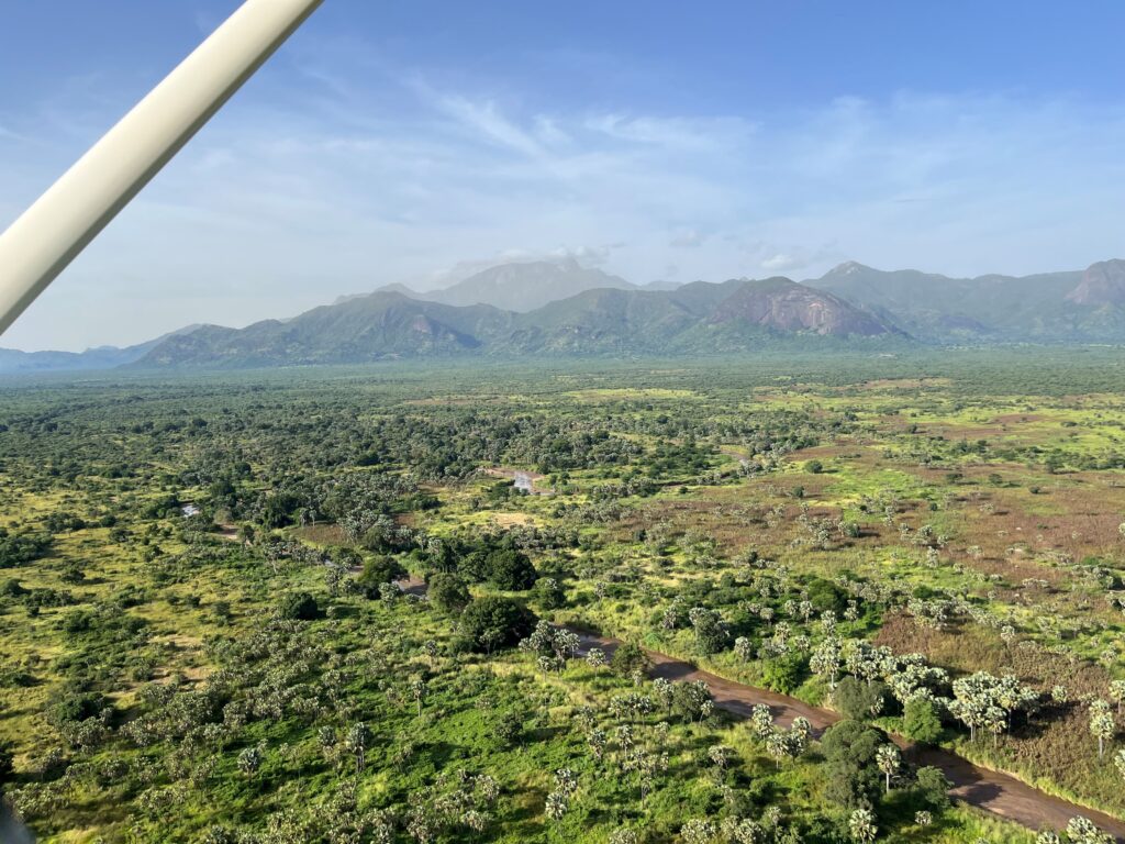
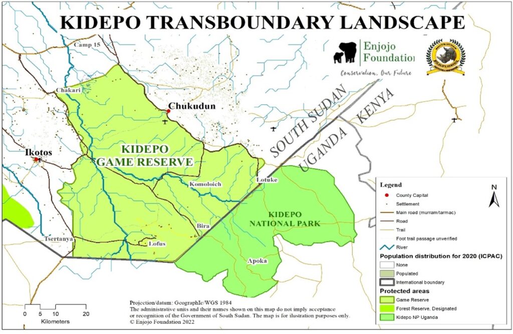
Established in 1975 with an area of about 280 000ha (2800km2), Kidepo Game reserve falls under IUCN Management Category: VI = Protected area with sustainable use of natural resources (IUCN, 2022). The reserve lies between the Dongatona Mountains to the west and the Didinga hills to the east, while to the north it is bounded by the Chakari – Farasika imaginary line and to the south by the Uganda border. The Reserve’s central feature is the Kidepo Valley, which meanders into the adjoining Kidepo National Park on the Ugandan side of the border. The Reserve is an integral part of the wider Kidepo Valley transboundary ecosystem, bordering Kidepo National Park in Uganda and adjacent protected areas, which is an important contiguous protected area in Eastern Africa.
Kidepo Game Reserve possesses an impressive scenic landscape containing a number of different habitats, including sand bed rivers, inselbergs and mountains. Expansive grassy plains are dotted with big rocky outcrops and flanked by steep jagged mountains and inselbergs from which one can obtain stunning views in all directions. The vegetation can best be described as open tree savannah which varies much in structure and composition – mosaic of savanna, grassland, and woodland habitats and dense thickets. Acacia short-grass savanna predominates in the plains. There is currently no known river or swamp holding water through the year. Dry riverbeds zig zag across the reserve, with Kidepo Riverbanks covered by riverine vegetation of Borassus palm trees. Low ranges of rocky hills are covered in scrub. The Dongatona Mountains and Didinga Hills are covered with montane forest and shrubland. This mosaic provides a diversity of resources for wildlife. As such, the area could represent an important refuge for rare, endangered and/or endemic species to this biogeographical region.
The Reserve used to support populations of critically endangered Nubian Giraffe, endangered elephant, wild dog and vulnerable cheetah, as well as other rare species as roan antelope, Beisa oryx, aardwolf, and striped hyena. It was acclaimed as an important elephant area in the 1950s through the 1980s, where elephants were observed to move between Kidepo Game Reserve in Sudan and Kidepo National Park on the Ugandan side of the border.
Kidepo Game Reserve is currently the only protected area in South Sudan covering semi-arid habitat type, that if protected could support important biodiversity. Today’s low levels of wildlife are due to intensive hunting pressure and seasonal lack of water.
The reserve is home to different agro-pastoralist ethnic groups, including the Ketebo, Lorwarma, Logir, Dongotono and Lotuko in Ikotos county, and the Didinga and Buya in Budi County. These ethnic groups are agro-pastoralists and use the reserve as a grazing land for their cattle. Each of these peoples have distinct traditions, culture, and livelihood activities.
Lantoto National Park, South Sudan

Established in 1986, Lantoto National Park (1547 km2) forms a contiguous protected area with the Garamba Complex sharing a common border of approximately 98 km along the Congo‐Nile watershed divide. The aerial survey carried out in November 2022 confirmed an untouched scenic landscape of densely forested savanna and forest and a low human footprint. Despite the high levels of poaching, its position at the interface between the Sudanian-Guinean Savanna and Congolian Forest bioregions underly the potential for conservation initiatives. A well-managed and secured Lantoto will have a significant positive impact for the biodiversity of the Lantoto-Garamba Landscape as a whole.
The park was named by the Sudan’s central government in the Wildlife Act of 1986 and Wildlife Conservation and National Parks Act of 2003. After attaining its independence on 9 July 2011, the Government of the Republic of South Sudan did not carry out gazettement of the park. However, the Ministry of Wildlife Conservation and Tourism has plans to gazette the Park and re-align its boundaries.
Lantoto National Park is known to have historically supported wildlife populations ranging from Giant Eland (Tragelaphus derbianus), Red -flanked Duiker (Cephalophus rufilatus), Bushpig (Potamochoerus porcus), Blue Duiker (Cephalophus monticola), Bush Duiker (Sylvicapra grimmia), African hunting dog (Lycaon pictus), Colobus monkey (Colobus abyssinicus), Temminck’s ground Pangolin (Manis temmincki) ((Hillman, 1982). There is high probability of presence of Chimpanzees in the canopy high forest based on observer communications and probable nest sightings (Matkoski, pers. Comm., 2022). The savanna areas are known to have once supported large populations of African buffalo (Syncerus caffer), giraffe (Giraffa camelopardalis antiquorum), and several antelope species. Large carnivores including the lion (Panthera leo), spotted hyena (Crocuta crocuta) and leopard (Panthera pardus) are still reported by the communities to be present in the park. Satellite tracking has indicated that several elephant herds migrate into Lantoto for parts of the year from Garamba.
Administratively, the Park falls under Yei and Maridi County. There are 6 villages bordering the Park with 4 different tribes: the Baka, Avokaya, Mondo and Adio.
